This is what the latest GFS mdel said: http://www.nco.ncep.noaa.gov/pmb/nwprod/an...2/fp0_120.shtml
+7
forpetessake
jdrenken
Craig-OmahaWX
Thundercloud
tornadoresearch15
centralplainsstorm
Chicago Storm
11 posters
Apr. 17-18th Severe Weather Possibility
Chicago Storm- Admin
- Posts : 70
Join date : 2008-04-11
Location : Streamwood, IL
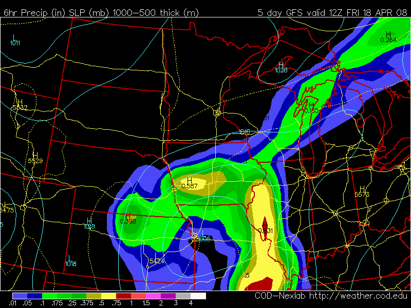
There chance for severe weather on Thursday and Friday looks to be increasing.
This is what the latest GFS mdel said: http://www.nco.ncep.noaa.gov/pmb/nwprod/an...2/fp0_120.shtml
Chicago Storm- Admin
- Posts : 70
Join date : 2008-04-11
Location : Streamwood, IL
I was looking over the GFS indices for this storm and the temps. are expected to be in the 70's, there will be dew points around 60F, and a good amount of SPC CAPE. So it looks like there will be a good chance for severe storms in Texas, Kansas, Oklahoma, Missouri, Iowa, Nebraska, Illinois, Wisconsin, and Arkansas.
centralplainsstorm- Thunderstorm
- Posts : 38
Join date : 2008-04-13
Age : 33
Location : Ottawa, Illinois
i know this is kind of old but it is the latest:
http://www.nco.ncep.noaa.gov/pmb/nwprod/analysis/namer/gfs/18/fp0_120.shtml
Chicago Storm- Admin
- Posts : 70
Join date : 2008-04-11
Location : Streamwood, IL
GFS is showing a nice line of storms.centralplainsstorm wrote:i know this is kind of old but it is the latest:
http://www.nco.ncep.noaa.gov/pmb/nwprod/analysis/namer/gfs/18/fp0_120.shtml
tornadoresearch15- Thunderstorm
- Posts : 14
Join date : 2008-04-13
Age : 32
Location : Champaign/Urbana, Illinois
Something to keep an eye on. A lot of time to pass, but looks promising. Hopefully I can have better luck on this outbreak than thursday's outbreak. Such a big failure that was
Thundercloud- Thunderstorm
- Posts : 24
Join date : 2008-04-14
Age : 33
Location : Rochester, NY
well at least we know that whereever SPC has moderate risk equals very low risk and where they have very low risk (5-10%) equals the high risk
Chicago Storm- Admin
- Posts : 70
Join date : 2008-04-11
Location : Streamwood, IL
Well this little storm is not looking good at all. Just looks to be a wave along the front that produces some thunderstorms with hail and heavy rains.
Thundercloud- Thunderstorm
- Posts : 24
Join date : 2008-04-14
Age : 33
Location : Rochester, NY
Chicago Storm- Admin
- Posts : 70
Join date : 2008-04-11
Location : Streamwood, IL
We will see what the 18z models say...so far the NAM just shows a wave alnog the front, nothing big.
Thundercloud- Thunderstorm
- Posts : 24
Join date : 2008-04-14
Age : 33
Location : Rochester, NY
I know this will likely only be a slight risk event
Chicago Storm- Admin
- Posts : 70
Join date : 2008-04-11
Location : Streamwood, IL
Slight risk or a "see text" event. Still a couple of days out though.
Craig-OmahaWX- Thunderstorm
- Posts : 1
Join date : 2008-04-12
I doubt this will be eventful
Chicago Storm- Admin
- Posts : 70
Join date : 2008-04-11
Location : Streamwood, IL
The GFS showed a nice line of storms on Friday from Chicago to Arkansas.
jdrenken- Thunderstorm
- Posts : 17
Join date : 2008-04-13
Age : 50
Location : Central Missouri
Decent SLI's don't go any farther North than Fort Smith, AR.
Thundercloud- Thunderstorm
- Posts : 24
Join date : 2008-04-14
Age : 33
Location : Rochester, NY
when you get too far south you will be too far away from the low pressure
Chicago Storm- Admin
- Posts : 70
Join date : 2008-04-11
Location : Streamwood, IL
Still a couple of days out to be talking to be talking in depth about it. Overall not a big event, but there will be some severe storms.Thundercloud wrote:when you get too far south you will be too far away from the low pressure
Thundercloud- Thunderstorm
- Posts : 24
Join date : 2008-04-14
Age : 33
Location : Rochester, NY
I am thinking an event like the first low of the last event where there are about 5-7 supercells then a line of storms and then done although there may be snow on the north side again
forpetessake- Thunderstorm
- Posts : 2
Join date : 2008-04-14
Well my guy at the NWS site is say spotters are not required for this event. So I dont know. Doesnt look too promising.
White Lighten- Thunderstorm
- Posts : 1
Join date : 2008-04-14
Both the GFS and ECMWF show a minimal severe threat coming across parts of the Nation on the 18th-20th. At this time it looks to only be a minimal threat with a few tornadoes, damaging winds, and hail reports, but I do not forsee a large and devestating outbreak. In fact I am being quite conservative I think in calling it a minimal threat, because while the upper level winds maybe directional and supportive of a tornado threat the speed of the shear is quite low and only maxing out in the 65-85knt range. Instability is very minimal and will most likely be confined to areas across the Plains/ MS. Valley/ and Southeast, but a few hailers could occur up in the Ohio Valley or maybe a damaging wind or two event. Overall, if there is anything that I see spectacular occuring in this event would be the amount of warnings that maybe issued and the actual amount of storm reports that come in. But, always keep in the back of your mind that things can change especially with this system as there is a lot of uncertainities between the GFS and ECMWF.
I'll keep you posted on my latest thinkings.
tornadoresearch15- Thunderstorm
- Posts : 14
Join date : 2008-04-13
Age : 32
Location : Champaign/Urbana, Illinois
Only time will tell. I'm hoping for some tornadoes in my area, but I tend to agree with you all. The stuff isnt there for this to be too significant of an putbreak. Hopefully late April and May can bring us huge outbreaks!
centralplainsstorm- Thunderstorm
- Posts : 38
Join date : 2008-04-13
Age : 33
Location : Ottawa, Illinois
ok Chicago never says they are needed until the SPC issues a risk for severe weather, or your are the night before/ the day of...they never say they are required several days awayforpetessake wrote:Well my guy at the NWS site is say spotters are not required for this event. So I dont know. Doesnt look too promising.
centralplainsstorm- Thunderstorm
- Posts : 38
Join date : 2008-04-13
Age : 33
Location : Ottawa, Illinois
http://www.nco.ncep.noaa.gov/pmb/nwprod/analysis/namer/nam/00/fp0_084.shtml
new NAM has a nice line of storms plowing through
http://www.nco.ncep.noaa.gov/pmb/nwprod/analysis/namer/nam/00/fp0_084.shtml
new NAM has a nice line of storms plowing through
Dominic- Thunderstorm
- Posts : 9
Join date : 2008-04-14
Age : 35
Location : Chicago
centralplainsstorm wrote:http://www.nco.ncep.noaa.gov/pmb/nwprod/analysis/namer/nam/00/fp0_084.shtml
http://www.nco.ncep.noaa.gov/pmb/nwprod/analysis/namer/nam/00/fp0_084.shtml
new NAM has a nice line of storms plowing through
Yeah. Decent 500mb energy that closes off. Could see some decent severe wx out of this across IL
Chicago Storm- Admin
- Posts : 70
Join date : 2008-04-11
Location : Streamwood, IL
The NAM looks better on the 00utc run than the 18utc run. It now has a decent outbreakDominic wrote:centralplainsstorm wrote:http://www.nco.ncep.noaa.gov/pmb/nwprod/analysis/namer/nam/00/fp0_084.shtml
http://www.nco.ncep.noaa.gov/pmb/nwprod/analysis/namer/nam/00/fp0_084.shtml
new NAM has a nice line of storms plowing through
Yeah. Decent 500mb energy that closes off. Could see some decent severe wx out of this across IL
Chicago Storm- Admin
- Posts : 70
Join date : 2008-04-11
Location : Streamwood, IL
The SPC on day 3(Thursday) shows only a see text. Not looking to be a good outbrack, as all the dynamics will not come together.
|
|